Coniston Copper Mines (Paddy End / Levers Water mine)
5 August 2013

Matt Ewles
A splendid weekend in the Lakes and a first class mine trip
We were not sure what to expect from the Coniston Copper mines, having struggled to find any good online descriptions, a number of conflicting GPS coordinates and what appeared to be multiple different names for the same mine, and none of the descriptions providing adequate details to act as a walkthrough! Nonetheless, we had a great day. Hopefully the following report might be of more use to any other Coniston newbies like us planning a first mine visit to the area.
We headed up to The Lakes Friday night, camping at Birch Bank near Blawith about 7-8 miles from Coniston Water itself. We opted for this as it was less likely to be full of screaming tourists and midges than the campsites in Coniston itself. It was a superb campsite, very cheap, friendly, happy to accept cavers, and benefits from having two separate fields, one near the farmhouse for the normal campers and one 200m before you reach the farmhouse on the right for people like us who like a bit of isolation from the masses and are arriving quite late in the evening so don't want to disturb people. The ground is quite hard so don't forget your tent peg hammer, plus it is quite an exposed place in terms of the wind (the normal bit of the campsite is more sheltered). But the views are amazing, 360 degree stunningness!
Saturday morning we headed up to Coniston. We weren't sure where to park and we ended up parking at a village car park for an extortionate £6.50 for the day (thieving beggers). We know now that there plenty of on-street parking available if you arrive early enough. The best place seems to be to take the road signposted towards the Youth Hostel (about 50m north of the bridge on the main road through town, next to the pub). About 200m up this road you can park on the left against the wall. Alternatively, it may be possible (and would save 45 min off the walk) to arrange in advance to park at the Youth Hostel which is about a mile drive up this road (which soon degenerates into a track). I'm not sure what the restrictions are on this.
We had several vague descriptions but none of them particularly useful navigationally, but we decided to go for Paddy End (also known I think as Levers Water mine) with a possible view to coming out of Hospital Level. Many people seem to do this as a pull through but as we didn't know the way we thought we'd do it as a down-and-up trip. We packed the ropes (the three pitches are apparantly 28m, 21m 21m, so we packed generously above this) and headed up the footpath towards the copper mines. About 45 minutes walk later you arrive at the coppermines Youth Hostel and are confronted with various routes heading off. We knew we wanted to be heading towards Levels Water, however, somehow we ended up taking a path up the hillside towards Low Water instead. After realising our mistake, we eventually reached Levers Water after a walk of some three hours. The walk was extremely scenic but next time I'll not be doing it in wellies. From Levels Water the entrance is obvious.
For reference, the correct route is to follow the very obvious path gently ascending north west directly towards Levels Water from the Youth Hostel up the right hand side of the valley (NOT the path going towards the active quarry to the west). A GPS or compass would probably be of benefit here to ensure you don't make the same mistake as us. At the top when you reach Levers Water (on it's eastern corner) cross the river coming from the lake (following the lake clockwise) and about 200m ahead is the large obvious fenced depression of the mine. There are three entrances in the depression. The right hand one looks like a hobbits house and is locked. The largest middle entrance is a large rift (a mineral vein) called The Funnel which is apparantly certain death, and the left hand one, a smaller vein, is the correct one.
Heading into the rift you maintain daylight for a minute or two before reaching a handline scramble down to the head of an in-situ ladder, followed shortly by another ladder. Then we were confronted by the first of the mines interesting obstacles. A steep descent further down into the vein was made possible by some (fairly new) wooden stemples acting as ladder rungs jammed between the walls. Words don't really do this justice, and it was very entertaining. An in situ rope provides some reassurance!

From the floor, a wire traverse over a dodgy false floor ahead immediately reaches the first pitch with two hefty eyebolts (in good condition) to rig off and some in-situ PVC as a rope protector. This was an easy to rig pitch and we were quickly down to the next level of the mine some 20m below. Unfortunately we were immediately confronted by the next pitch. This too had two good condition anchors. Unfortunately Gary got a few metres down and it was clear that there was going to be lots of rope rub a few metres below the anchors and then possibly again further down. The mine is bolted purely for the pull-through and not for those wishing to go down then up. The rock on which the rope was rubbing was gritty so something had to be done. The rub point was too far below the anchors to simply hang a tacklesack between the rope and the rock (it would have simply popped out from behind the rope). Ideally we needed a tacklesack with a large hole in the bottom to use as a giant tube to put the rope through, but for once, we were underground with our two newest tacklesacks which had no holes (and considering what they cost we weren't about to make any holes). There was nothing that would work as a deviation either. We decided to go for safety-first and so we turned back vowing to return with rope protectors (or a knackered tacklesack).
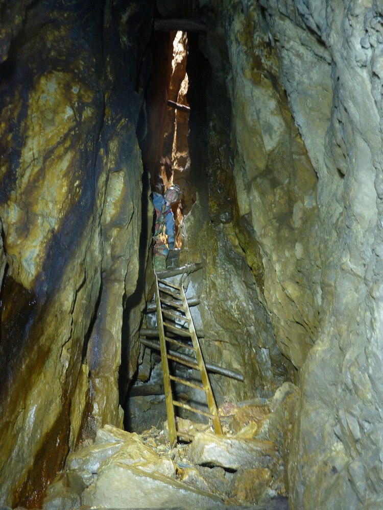
Up the first pitch and across the false floor, we decided to explore a slightly unobvious route going off as a stoop/crawl underneath the stempled rift climb. There are two passages going off, we took the right which passes under some wooden supports holding up lots of rock before reaching something quite remarkable. Ahead of us lay a 20m deep shaft, extending some 10m across the entire floor of the rift and with passage continuing on the other side. The extremely dedicated group that maintain this place have installed yet more wooden stemples and a safety line over this shaft. Again, words do not explain this well (perhaps the photos do) but crossing this certainly gets your heart going, and involves edging one stemple after another across the very deep shaft.
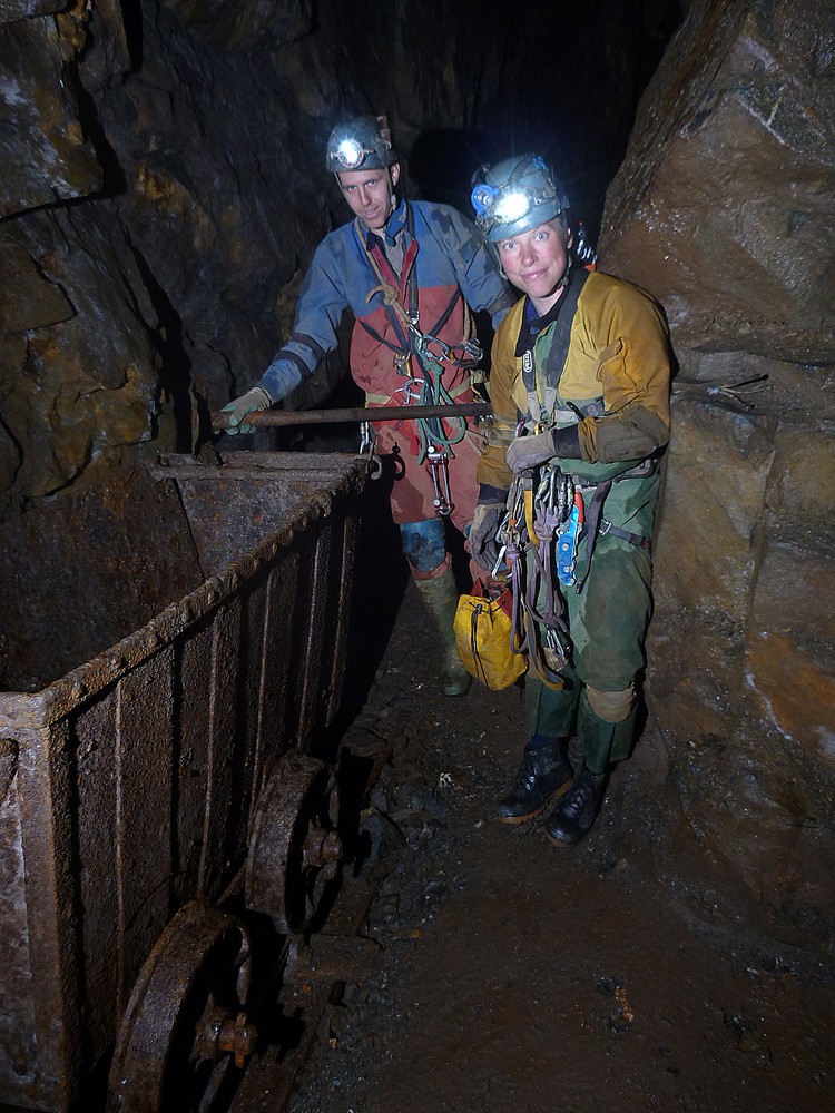
Beyond here a number of passage lead off, mostly walking, with some superb blue flows of copper and calcite. One route drops down an excavated shaft with handline into the 1987 extensions (we know this 'cos there was a sign telling us) which eventually reach a superb chamber where a tub has been restored on its rails (see photos). This was truely superb! We took some photos, and with time ticking on and a pub meal beckoning we headed out, leaving several possible onward routes unexplored.
Next time we will come back better prepared, knowing firstly where the mine is, and secondly that in addition to the ropes you also need a selection of rope protectors or a tacklesack with a hole in the bottom to function as a protector for the second pitch. From what I read of the description we had, the most spectacular stuff is yet to come at the bottom of this pitch so there's plenty of inspiration for a return visit next year. Plus this mine is apparantly just the tip of the iceberg!
A remarkable day out, superb scenery and a first class mine!
More articles
North York Moors valley to valley trip becomes a reality
By Matt Ewles | 13 Apr 2026
Exploration of the Excalibur MEGA extensions
By Matt Ewles | 14 Aug 2025
Excalibur streamway extended!
By Matt Ewles | 7 Aug 2025
Jenga vocally connected to River Dove valley!
By Matt Ewles | 24 Jul 2025
Dan-yr-Ogof Far North
By Matt Ewles | 27 May 2025
Brown Hill Pot
By Matt Ewles | 22 Apr 2024
Sunny Bank Holiday in Wales
By Matt Ewles | 5 Jun 2023
Avoiding the January Blues in Rift Pot
By Tash Durham | 16 Jan 2023
North Wales Slate Mines 2022
By Matt Ewles | 5 Dec 2022
Long Churn beginners trip. 10th October 2022
By Conor Morrison | 11 Oct 2022